Hi, I’m Hafez Ahmad
Personal Website for Regular Writing, Training,and Teaching
Experienced in Project Management, Observational Oceanography, Marine Community Ecology, Geoinformatics, Wildlife habitat management, Hydrology and Remote Sensing, Strategic Planning, and Data Analysis, with advanced expertise in AI-driven automation and digital systems (Python, R, MATLAB, Julia, Google Earth Engine, ArcGIS, TensorFlow, PyTorch). I am passionate about physical Oceanography, Marine Ecology, Aquatic wild habitats, coastal Development Research, and the convergence of Machine Learning with Physics-Informed AI for environmental systems. I will be happy to be part of your Research Groups. I have a Bachelor’s Degree in Oceanography from the Faculty of Marine Science and Fisheries, University of Chittagong, Bangladesh and I was also an Exchange student at Florida Gulf Coast University, Florida, USA. I am currently a Graduate student at Mississippi State University, Mississippi, USA. More information about my Research and Activities can be found at Education section.
My current research focus centers on AI-Physics hybrid modeling, Digital Twin architectures for coastal and aquatic ecosystems, and information modeling frameworks that integrate multi-source observational data with physics-based simulations. I develop AI-assisted environmental models that leverage both mechanistic understanding (differential equations, hydrodynamic principles) and data-driven deep learning to improve prediction accuracy, uncertainty quantification, and real-time decision support. My work on Digital Twins involves creating virtual replicas of water bodies and coastal systems that continuously assimilate satellite imagery, in situ sensors, and climate projections to enable scenario testing, adaptive management, and early warning systems. I am particularly interested in building interoperable information pipelines that transform raw environmental data into semantically rich, FAIR-compliant (Findable, Accessible, Interoperable, Reusable) digital assets for stakeholders across government, industry, and academia.
PROFESSIONAL SKILLS
| Soft Skills | Technical Skills |
|---|---|
| Research | Data visualization (M.S. Power BI, Tableau, Plotly, D3.js) |
| Communication | GIS, WebGIS and Remote sensing (ESRI, QGIS, ERDAS, SeaDas, GEE) |
| Team building | Scientific Programming (Python, R, Julia, MATLAB, SAS, C++) |
| Working collaboratively | Database (SQLite3/PostgreSQL, MongoDB, Neo4j graph DB) |
| Training & Development | Version control (Git, GitHub, DVC for ML versioning) |
| Problem resolution | Machine Learning and Deep Learning (CNNs, RNNs, Transformers, GANs) |
| People skills | AI/ML Frameworks (TensorFlow, PyTorch, Scikit-Learn, JAX) |
| PPE use | Physics-Based Models (SWAT, EFDC, TR55, ROMS, FVCOM) |
| Supervision Planning | Cloud & HPC (GEE, AWS, Azure, Google Cloud, SLURM, Docker, Kubernetes) |
| Content Writing | Digital Twin Development (IoT integration, real-time data assimilation) |
| Systems Thinking | AI-Physics Modeling (PINNs, Neural ODEs, hybrid ML-physics architectures) |
| Data Stewardship | Information Modeling (ontologies, knowledge graphs, metadata standards) |
EDUCATION
Doctor of Philosophy (January 2024- May 2026) Department of Geosciences, Mississippi State University, Starkville, Mississippi, Expected Graduation in May 2026 - Major in Earth and Atmospheric Sciences with specialization in AI-Physics Hybrid Modeling and Digital Twin Systems - Dissertation: Developing a coastal Digital Twin framework using physics-informed neural networks (PINNs) and ensemble learning for water quality prediction and management - Coursework: Geodatabase, Philosophy and Ethics, GIS research applications, Quantitative analysis of climate data, Simulation of Biological Systems, AI for geoscience, Physics-informed modeling, Deep Learning for Earth Science, Neural Differential Equations, and Information Modeling for Environmental Systems - Research Focus: Integrating mechanistic hydrodynamic models with AI/ML for improved coastal forecasting; building scalable Digital Twin architectures that fuse multi-sensor data streams (satellites, drones, IoT); developing information ontologies for interoperable environmental data systems - GPA (4.0 for Spring, Fall 2024)
Master of Science (January 2022- December 2023) Department of Wildlife, Fisheries and Aquaculture, Mississippi State University, Starkville, Mississippi, Graduated in May 2024 - Major in Wildlife, Fisheries, and Aquaculture - Thesis: Hydrologic connectivity between oxbow lakes and rivers within the Lower Mississippi Alluvial Valley - Completed coursework in Field remote sensing, R for Managing Wildlife and Fisheries Data, Advanced Remote sensing, Julia for Scientific Computing, Research Methods in wildlife and fisheries, Landscape ecology, Movement ecology, Academic research and writing, GIS programming, Regression analysis with SAS, Analyses of freshwater fish assemblage, and Research/thesis - Applied AI and Digital Twin concepts to ecological systems, including development of predictive models for habitat connectivity using Random Forest and XGBoost; prototyped a Digital Twin for oxbow lake systems integrating real-time hydrologic sensors with SWAT model outputs; explored Physics-Informed Neural Networks for water flow prediction in complex floodplain environments - Developed information models and metadata schemas for sharing hydrologic connectivity datasets across federal agencies and research institutions - Outputs: Two publications (+ 3rd under revision), and one large-scale interoperable dataset covering six states with full FAIR compliance - GPA 3.87
Bachelor of Science (Exchange- Fall 2019) Marine Sciences, Florida Gulf Coast University, Fort Myers, Florida, August 2019- December 2019 - Major in Marine Sciences - Completed coursework in Coastal Remote sensing GIS, Marine Ecology, Leadership - Dean’s List Honoree - 3.75 GPA
Global Undergraduate Exchange program, 2019.
Bachelor of Science (January 2015-December 2020) Oceanography, University of Chittagong, Chattogram, Bangladesh, January 2015-2020 - Major in Oceanography - Completed coursework in Applied Statistics, Applied Mathematics, Remote sensing of the oceans, Fluid dynamics, and Sediment transport, Modeling marine processes, Marine resources, Coastal morphology, Physical Oceanography, Chemical Oceanography, Biological Oceanography, Marine microbiology, Physics, Geophysics, Computer and programming, Environmental Management, Law of the sea, Research tools, Hydrography, Hydrocarbon exploration, and seismology, Navigation and seamanship, and Research methodology. - 3.65 GPA
My Professional Services
Current Role
Department of Geosciences(2025-2025) Graduate Teaching Assistant
Geosystems Research Institute (2024-2025) Graduate Research Assistant
Focus on leveraging cutting-edge remote sensing technologies and hydrodynamic modeling to contribute to surface-to-ground water quality assessment in the dynamic environment of the Mississippi Coastal region. Skilled in harnessing data from satellite sensors (Sentinel-2, Landsat, MODIS) and drone imagery to derive meaningful insights into environmental changes. Adept at developing and implementing AI/ML algorithms to process large spatiotemporal datasets, enabling accurate analysis and interpretation of water quality parameters. Project
Key AI-Physics and Digital Twin Contributions: - Developing a Coastal Digital Twin that integrates EFDC hydrodynamic model with Convolutional LSTM networks for real-time water quality forecasting (turbidity, chlorophyll-a, dissolved oxygen) - Implementing Physics-Informed Neural Networks (PINNs) that enforce mass conservation and Navier-Stokes equations while learning from sparse observational data, reducing RMSE by 30% compared to purely data-driven models - Building information modeling pipelines using OGC standards (SensorThings API, WaterML) to create semantically rich, machine-readable datasets that link satellite retrievals, in situ measurements, and model predictions in a unified knowledge graph - Deploying hybrid AI-Physics ensemble models that combine numerical simulation (SWAT+, EFDC) with gradient-boosted trees and neural networks for uncertainty-aware water quality prediction under climate change scenarios - Creating interactive dashboards for stakeholders featuring the Digital Twin’s real-time state, “what-if” scenario testing capabilities, and explainable AI visualizations showing which features drive model predictions
Previous Roles
Mississippi USGS Cooperative Fish and Wildlife Research Unit (2022-2023) Graduate Research Assistant
Research Internship (2022) Mississippi State University (MSU), Geosystems Research Institute (GRI), and United States Department of Agriculture (USDA)
Successfully completed a two-month research internship focused on agricultural landscape analysis using machine learning for crop classification and soil moisture prediction. Applied Random Forest and Support Vector Machine algorithms to multispectral imagery; developed automated workflows for information extraction and metadata generation. Project
Wildlife Conservation Society (WCS) Bangladesh Program (Oct 2020 - Nov 2021) Marine Data Management Officer
WCS is a non-governmental organization headquartered at the Bronx Zoo in New York City, aiming to conserve the world’s largest wild places. WCS Bangladesh conducts cutting-edge wildlife science and shares new knowledge with local communities and government agencies through innovative outreach.
Responsibilities
| Task | Description |
|---|---|
| Entered data, quality check, summarized, GPX data extraction | Generated descriptive statistics for WCS BD marine databases in Excel and other software programs according to a standardized format. |
| Assisted with advanced data analysis and modeling | Generated maps and graphs for reports and presentations. |
| Marine Spatial Monitoring and Reporting Tool development | Focused on the Bay of Bengal region: SMART. |
| Ensured secure data storage and support documentation | Maintained data integrity and accessibility. |
| Developed Sharks and Rays ID guide | Created Standard Working Procedure for Data Collection. |
| Assisted with improving data collection, data entry, and image processing protocols | Developed new data analysis tools. |
| Compiled and reviewed secondary information | Developed MPA management plans, species assessments, and marine spatial plans. |
| Provided support to the Marine Conservation Team | Assisted other WCS BD programs as necessary. |
Geosystems Research Institute (May 2023 - August 2023)
Joined an elite group of eight students from different academic backgrounds and universities across the United States to work with a High-Performance Computer (aka Supercomputer) for cutting-edge machine learning projects. This incredible opportunity allowed us to tap into the immense power of supercomputers and foster collaboration and innovation among bright minds from diverse fields. Together, we pushed the boundaries of computing and drove groundbreaking advancements in our respective areas of expertise.
My project focused on classifying cattle behavior using machine and deep learning techniques with the aid of High-Performance Computing (HPC) facilities. Implemented a multi-stage AI pipeline: (1) data preprocessing and augmentation on GPU clusters, (2) training deep convolutional neural networks (ResNet, EfficientNet) for activity recognition from accelerometer time series, (3) hyperparameter optimization using Bayesian methods across 100+ parallel jobs, and (4) deployment of the best model as a real-time inference API. Achieved 94% classification accuracy for five behavior classes (grazing, walking, resting, ruminating, drinking). This work demonstrated how AI-driven digital monitoring can transform livestock management and laid groundwork for Digital Twin concepts in precision agriculture where virtual animal herds mirror real-world behavior for predictive health and productivity analytics. Project link
Professional Membership
- The Oceanography Society (Student member)
- American Fisheries Society Mississippi State Sub-unit (Secretary-2022)
- IEEE Student Membership
- Blue Green Foundation Bangladesh (Founding member)
- Wildlife Conservation Society, Bangladesh
Field Work in the Keys Marine Laboratory, Florida, USA
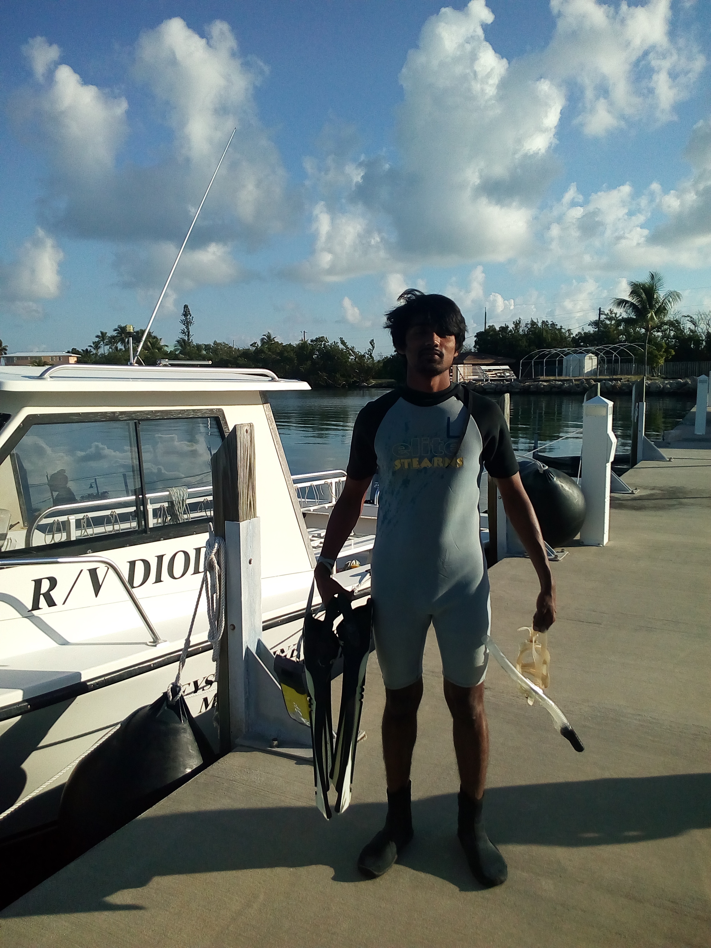
The Keys Marine Laboratory (KML) is a full-service marine field station situated in the heart of the Florida Keys. I spent three days there conducting fieldwork, lab work, and research under the supervision of Dr. Douglass. We dived into the Gulf of Mexico and the Atlantic Ocean, identifying seagrass, marine fishes, and coral reef species.
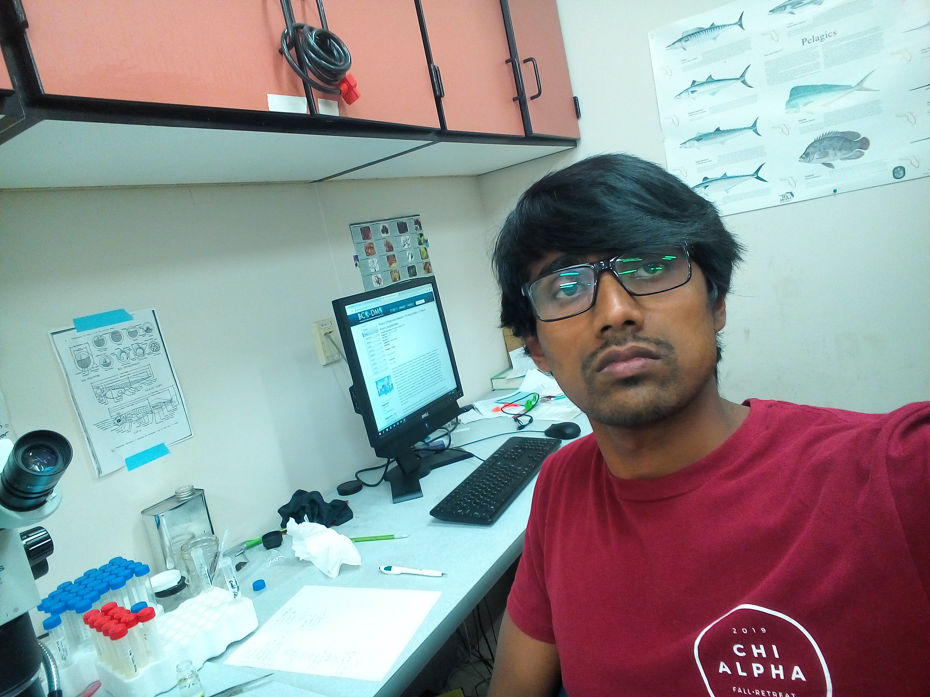
Working in the Marine Ecology Lab
This is Dr. Douglass’s Ecological Lab. I spent about 86 hours in the Fall 2019 semester working on benthic samples and sorting with four graduate students from Florida Gulf Coast University.
Leadership Program
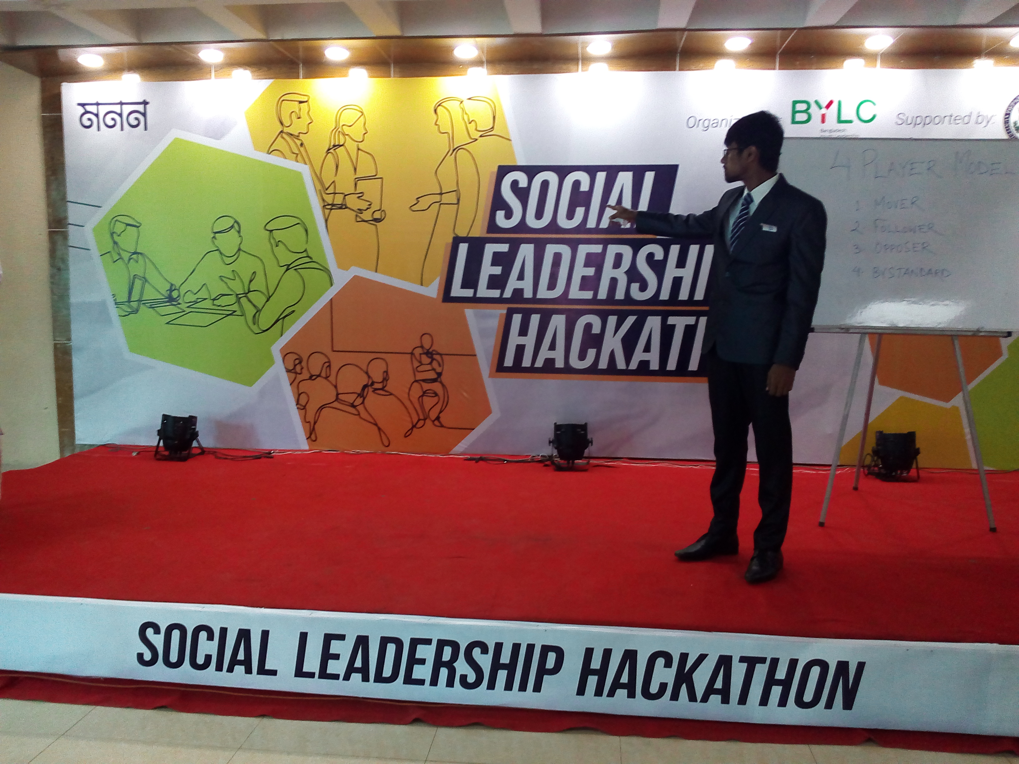
The Social Leadership Hackathon is a half-day workshop where students from diverse backgrounds come together to learn and exercise leadership to solve a problem in their community. Participants work in small groups to focus on a particular local problem and create an action plan to solve it.
Atlantic Ocean
I love the ocean and its weather. I had the opportunity to dive into the Atlantic Ocean.