Personal Website for Regular Writing, Training,and Teaching
Experienced in Project Management,Observational Oceanography,Marine Community Ecology, Geoinformatics, Wildlife habitat management, Hydrology and Remote Sensing,
Strategic Planning, and Data Analysis , and problem solving with automation (Python, R, MATLAB, Julia, Google Earth Engine, ArcGIS, Adobe Illustrator, Excel).
I am passionate about physical Oceanographic research ,Marine Ecology, Coastal water dynamics, Aquatic wild habitats ,Coastal Development Research and Machine learning . I will be happy to be part of your Research Groups.
I have a Bachelor’s and Master's Degree in Oceanography from the Faculty of Marine Science and Fisheries,
University of Chittagong ,Bangladesh and Mississippi State University, USA and I was also an Exchange student at Florida Gulf Coast University, Florida, USA.
I am currently PhD student at Mississippi State University, Mississippi, USA .
More information about my Research and Activities can be found at Education section.
I love to visit historical places in the world and I am a huge fan of the ocean.
Current Projects(*) and Completed Projects
Detection and tracking of mesoscale eddies in the Bay of Bengal using Satellite altimetry data *
Hydrologic and geospatial analyses to quantify surface-water connectivity of Lower Mississippi river and develop framework for evaluating tradeoffs between limiting invasion risks and maintaining hydrologic connectivity of oxbow lakes*
Applications of Machine learning in Computational Oceanographic Research *
Vulnerability of Sundarbans to Climate Change and Cyclone Intensification: Mapping, Dynamics and Future Change Analysis of Mangrove Forest Using Landsat Data. *
Simulation of the land use/land cover and land surface temperature change in the chittagong city corpoeration using QGIS*
Land use assessment and forecasting in the teknaf Upazila, Bangladesh.
Simulation of the future land use/land cover change in the Starkville, Mississippi,USA*
Vulnerability of Sundarbans to Climate Change and Increased storminess: Mapping and dynamics and future changes analysis of mangrove forest using Landsat analysis
Marine Spatial Planning to support Integrated Coastal zone Management in Bangladesh *
Spatio–temporal variability of SST,SSS and Primary productivity in the Bay of Bengal.
A case study for the Biodiversity Assessment and land cover in the Sundarbans mangrove forest.
Collaborative Research: The tropicalization of Western Atlantic seagrass beds (Volunteered in Dr. James Douglass(jdouglass@fgcu.edu)'s marine ecology lab )
Status and Future Trends of the Bangladesh Coastal Zone Management and coastal risks.
Present status of impacts of climate change and adaptations in Bangladesh coastal areas.
Vegetation and Land cover analysis in response to Precipitation and land surface temperature
of Oktibbeha County of Mississippi, USA
Integrated Management of Coastal Resources of Saint Martin’s Island in Bangladesh.
Google Scholar total citations 226, h-index: 4, and i10-index: 2,https://scholar.google.com/citations?user=ToH-NhkAAAAJ&hl=en [5/2/2022]
My Activities at a glance
Oceanographic Researcher
Ocean Remote Sensing and Satellite Data Analysis, Physical Oceanography,Ecosystem monitoring,Ocean Dynamics and Circulation,Bio-optics Oceanography Ocean productivity, Biological effects on Ocean's optical properties,Marine Pollution and Environmental Contamination,Coastal zone management, climate change,Climate hazards, SDM,EcoHydrology,connectivity, Estuarine processes, Aquatic wildlife habitats and Oceanographic data collection distribution of temperature and salinity,Coastal and Deep-ocean processes, up-welling, water mass formation and movement, ocean currents, interior and surface mixing, energy inputs and dissipation, surface and internal waves, and surface and internal tides.Marine Biodiversity , Ecosystem and Modeling
Nature conservation and Ocean Literacy
Nature Conservation is important for many reasons, not least of all to the health of the planet. However, the study of the subject goes merely beyond health and ecosystems.
I like to work with Nature and Nature based solutions projects. I did some conservation stuffs and Research in the coastal area of Bangladesh and
I love to teach Ocean Literacy and you can visit Our official website bgfbd .
Programming and Mapping
Many oceanographers grow up loving the sea and its creatures. but when It comes in Data analysis and Modeling , you have to gain programming knowledge. fortran is widely used langauge in ocean Model. then
During the last couple of decades, Matlab has been the most commonly-used scripting language in physical oceanography, and it has a large user base in many other fields.
Recently, however, Python has been gaining ground, often being adopted by former Matlab users as well as by newcomers. I have excellent working skill of Python ,Julia , R , Matlab, FORTRAN. ArcGIS , QGIS,SAGA,GRASS . you can find more in github repo
Traveling
I love traveling. Traveling makes you more open and accepting .
If you travel, you will not only learn about foreign cultures,
but about your own as well. You will notice the cultural differences,
and will find out what makes your culture unique. After retrurning from a long journey,
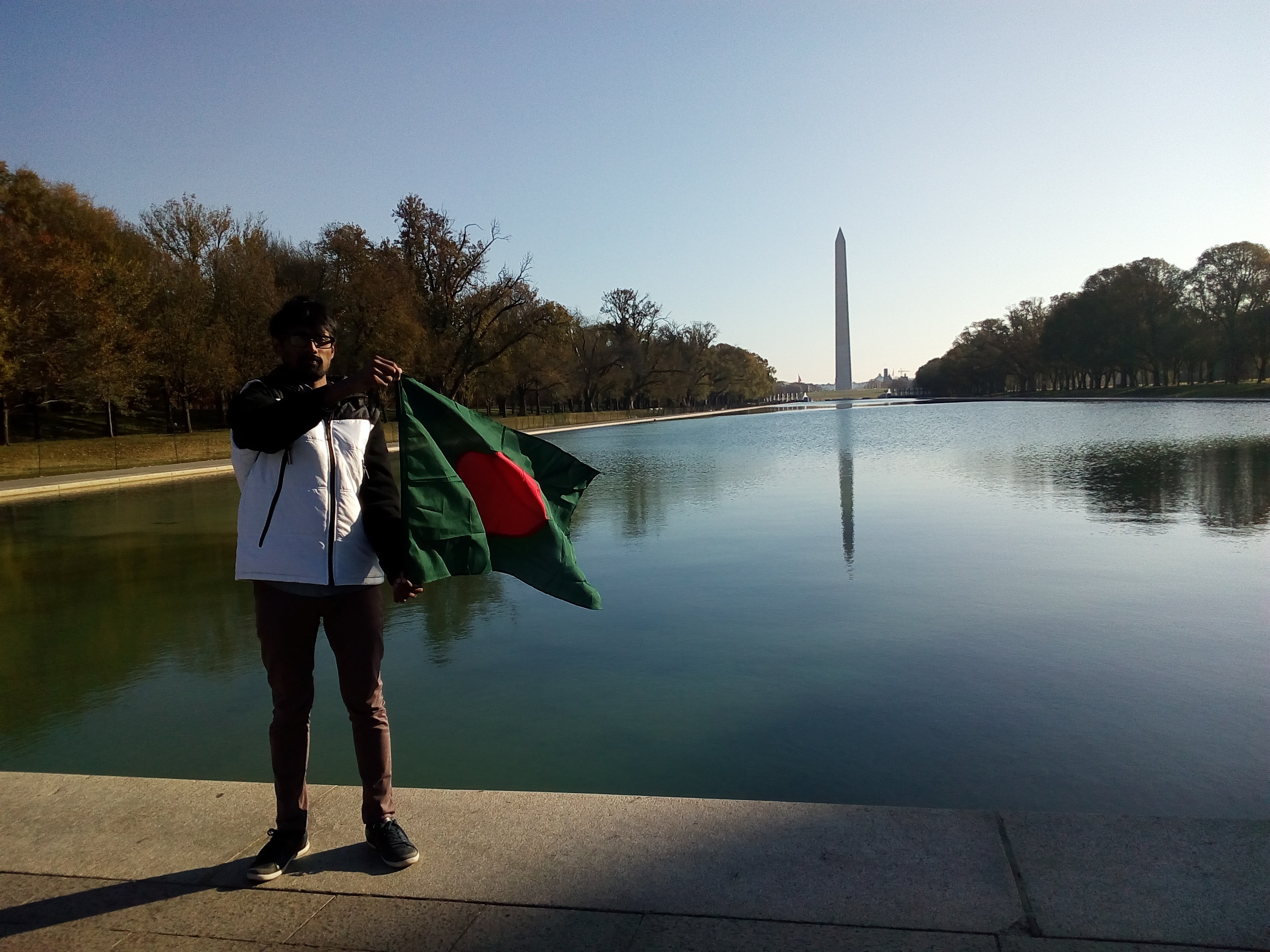
you will see your country with new eyes. I have visitied United States of America, Washington DC,
FLORIDA,New YORK ,Dubai,Qatar,Memphis,Birmingham,Athens, Saint Martin island , Cox'S bazar,sunburbans Mangrove.
About Me
Hafez Ahmad
I am a young Oceanographer.I am passionate about physical Oceanographic and Marine Ecology Research and coastal Development Research.
I use Python and R, MATLAB ,Julia,and C++ for data analysis, modeling, and visualization.I like do research and work with Physical Oceanography
, Ocean productivity, Biological effects on Ocean's optical properties), Coastal zone management, climate change
, Coastal Climate hazards and distribution of temperature and salinity, Coastal, Deep-ocean processes,
Acoustic Telemetry for Studying Migration Movements as well as computational Oceanography
.I am currently working on Machine learning applications, Marine spatial Planning, and Ocean Tracking and detection.
Completed Offline and online Training/ Courses
Training on “Regression and Hotspot analysis, 2018 ” at University of Dhaka, Bangladesh
Some of the themes addressed are in this practical Training :
Basic concepts of Regression and Hotspot analysis
Geospatial Data generation using ArcGIS 10. 5
Practical ways to identification of Crime- hotspot and uses geospatial Regression
"First Aid” in American corner, Chittagong, Bangladesh
Some of the themes addressed are in this practical Training :
Basic concepts of First Aid
Practical uses of the some first aid valid methods and instruments
Fishery Oceanography for Future Professionals
, during 16th - 20th November, 2020
Organized by International Training Centre for Operational Oceanography
(ITCOocean) ESSO-INCOIS, Hyderabad, India.
covered topics are
Oceanographic Processes
Nutrients, Productivity and Nutrient Cycles
Acoustics
Telemetry and e-DNA
Fish life-cycle and Oceanographic Processes
Mariculture and Oceanography
Anthropogenic Threats to Fishery Resources
SDGs for Youth: My Goal, My Responsibility” by Sudoksho and EMK Center, U.S. Embassy, Dhaka , Bangladesh
Participation in “Social Leadership Hackathon”
Geospatial Applications for Disaster Risk Management
Organized by United Nations Office for Outer Space Affairs, Centre for Space Science and Technology
Education for Asia and the Pacific (Affiliated to the United Nations) and Indian Institute of Remote Sensing (IIRS) under
Indian Space Research Organisation, Department of Space, Government of India
"Climate Change in practice and becoming global citizens for a sustainable society” by the Asian pacific center of education for international understanding and Ban ki-moon center.
Geospatial and Environmental Analysis by University of California, Davis
Julia Scientific Programming [with honors ] by the University of Cape Town
Introduction to GIS: Manipulating and Mapping Geospatial Data in R
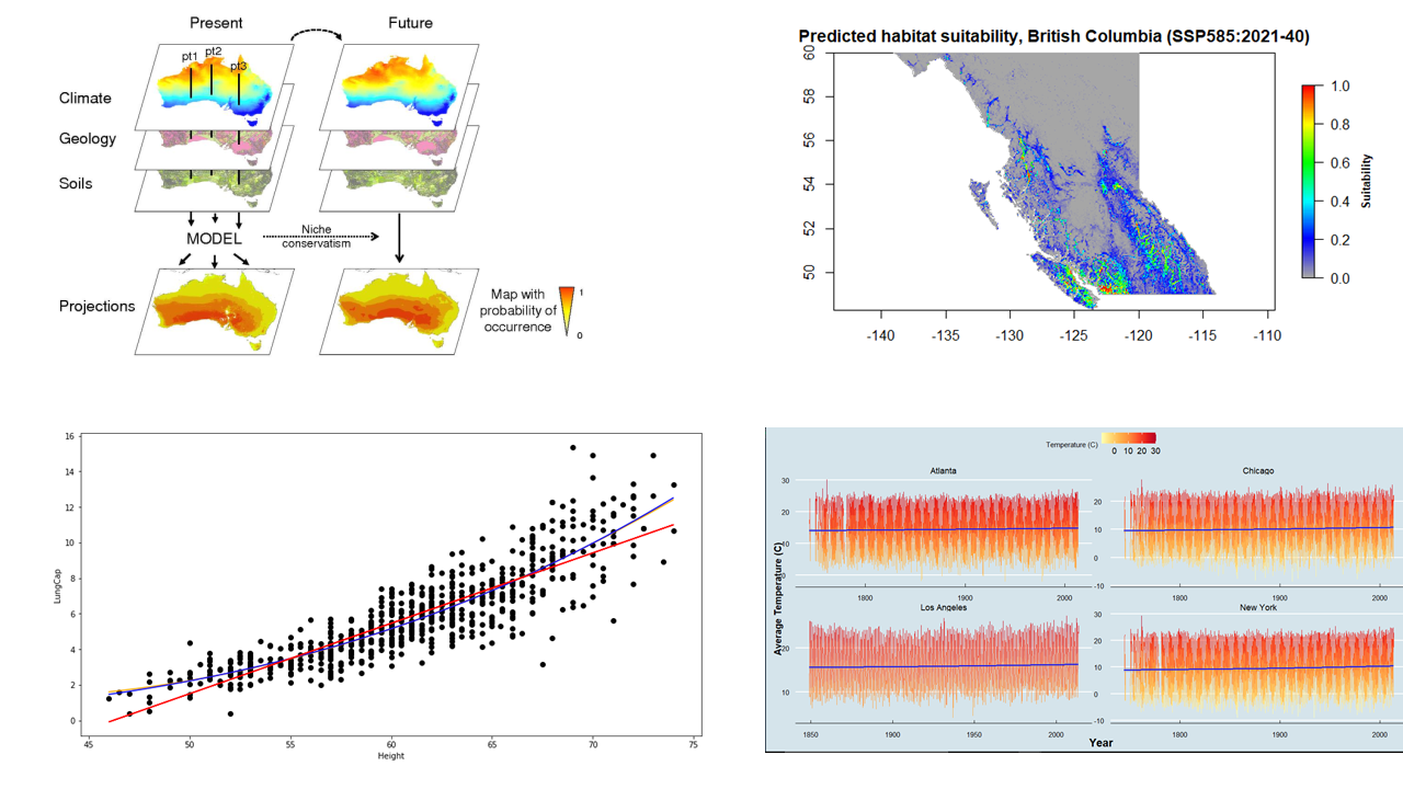
ARSET - Species Distribution Modeling with Remote Sensing
Biodiversity Applications for Airborne Imaging Systems,2023 ” by NASA Applied Remote Sensing Training Program (ARSET)
Lesson covered in this course
Overview of Species Distribution Models (SDMs), species data, predictors , model development
Using Wallace to Model Species Niches and Distributions
SDM comparisons and post-processing for conservation decision-making and beyond
Additional SDM Tools and Techniques, ASP Projects, and Summary
Circuitscape and Fisheries and Climate Toolkit (FaCeT)
Learned Advanced python Concepts
R programming hands-on specialization for data science
Become an expert with ESRI's GIS software ArcGIS desktop
Machine Learning Bootcamp™: Hand-On Python in Data Science
Ecology: Ecosystem Dynamics and Conservation
Large Marine Ecosystems: Assessment and Management
Data Analysis with Python
R Programming
Data Analysis with R Programming
Linear Regression and Modeling
Principles of Ocean remote sensing & its applications during July 26 - 30, 2021, Hyderabad, India
Learnings from this course
Principles of remote sensing
Thermal remote sensing & its applications
Ocean Colour remote sensing & its applications
Microwave remote sensing & its applications
Remote Sensing Data Sources and accessibility
Summer program on Climate Change: Challenges and Issues for the Earth Sciences “Institut Pierre-Simon Laplace Climate Graduate School", France
Some of the themes addressed are in this program :
The Climate System: a few decades that changed many things
New Trends in Climate Modeling: anticipating the future
Impacts and feedbacks of marine biogeochemistry and diversity
Exploring Earth observing systems and Models
The solar system: the sister planets of the Earth
Recent news from past climate
Preparing to Manage Human Resources
Marine Spatial Planning: balancing social, economic, cultural, and ecological objectives
Developing-your-emotional-intelligence
Excel 2016 Essential Training
MULTIVARIATE ANALYSIS in ECOLOGY (& other Sciences) using PRIMER version 7-2022
Some of the themes addressed are in this course :
Introduction to multivariate data; the data matrix, measures of resemblance, and
transformations
Multivariate regression; the regression model, the residuals, and the
prediction interval
clustering, Principal Component Analysis, and dimensionality reduction
Parametric and Nonparametric Multidimensional scaling, Second stage analyses, Taxonomic resemblance
Tests: RELATE, ANOSIM, BEST, SIMPER, SIMPROF ,BVSTEP and PERMANOVA
Project-management-foundations and Cert Prep: Project Management Professional (PMP)
I worked for Mississippi USGS Cooperative Fish and Wildlife Research Unit from 2022 to 2023 as Graduate Research assistant. Project
In the meantime, I successfully finished two months research Internship under Mississippi State University (MSU), the Geosystems Research Institute (GRI), and the United States Department of Agriculture (USDA) Project .
I worked (Oct 2020- NOV 2021) for Wildlife Conservation Society(WCS) Bangladesh Program as A Marine Data Management officer, WCS Bangladesh
WCS is a non-governmental organization headquartered at the Bronx Zoo in New York City, that aims to conserve the world's largest wild places.
And WCS Bangladesh conducts cutting-edge wildlife science. WCS then shares new knowledge with the local communities and government agencies through innovative outreach. My Responsibilities were
Entered data, quality check, summarized,GPX data extraction and generated descriptive statistics for WCS BD
marine data bases in excel and other software programs according to a standardized format.
Assisted with advanced data analysis and modeling and generate maps and graphs for
reports and presentations.
Marine Spatial Monitoring and Reporting Tool development for Bay of Bengal region: SMART
Ensured secure data storage and support documentation.
Development of Sharks and Rays ID guide and Standard working procedure for Data collection
Assist with improving data collection, data entry and image processing protocols, and
new data analysis tools.
Compiled and reviewed secondary information for developing MPA management plans,
species assessments and marine spatial plans.
Provided support to the Marine Conservation Team and other WCS BD programs as
necessary.
I worked (May 2023- August 2023) for Geosystems Research Institute, GRI, HPC
I joined an elite group of eight students from different academic backgrounds and universities across the United States to work with a High-Performance Computer (aka Supercomputer) for cutting-edge machine learning projects!
This incredible opportunity allowed us to tap into the immense power of supercomputers and fosters collaboration and innovation among bright minds from diverse fields. Together, we pushed the boundaries of computing and drive groundbreaking advancements in our respective areas of expertise.
My project focused on classifying cattle behavior using machine and deep learning techniques with the aid of High-Performance Computing facilities.
Project link
I use mainly Python,Julia and R, MATLAB ,Excel and C++ for data analysis and modeling, Geographic information system, remote sensing and visualization, Sometime, I use GUI based open source softwares and commercial softwares for the Professional works.
. additionally I like to write about the environment.
If you appoint in your work, I will do it very efficiently. I am diligent in my approach to ensuring that the work I do is completed to the highest standard.
I like to work closely with my clients to ensure that they receive the best possible service making your ideas a reality through an easy and efficient process
resulting in repeat business and a lasting relationship with the focus of understanding your business vision.
Hello World! My services include but not limited to the following:-
Desktop and Web Mapping and GIS such
Mapping of the study area
Density mapping
Contour map
Bathymetric mapping
Road mapping
Flood mapping and surface water dynamics
Hydrographic mapping
Topographic mapping
Hydrology connectivity Mapping
Volumetric mapping
Landslide Analysis
Digital Elevation Mapping
Landcover and landuse Map
Predictive Map with Machine learning and Deep learning
Land cover and change Map, Benthic Habitats classification and Mapping
choropleth map
Different indices based map like NDVI, NDWI, LDI etc.
Tracking Map
Hotspot analyses and Mapping
Sptial Regressional Mapping
Multidimentional data based Map
Ocean current Mapping
Spatial Bayesian analysis
Geo Data analysis , visualization and Modeling using ArcGIS,R,Python, QGIS, GRASS, SAGA.
Species Distribution Modeling with R/ ArcGIS
I have practical and research experience on species distribution Modeling.
I can do the using following method including machine learning models using R/ ArcGIS.
1. Maximum entrony [Maxent]
2. Generalized linear models
3. Boosted Regression Trees
4. Random forest
5. Support vector machine
Spatial Programming and in GIS using Python and R.
Sourcing and downloading Satellite Images, Satellite image classification including supervised and unsupervised.
GIS data file conversion — Convert from Shapefile to KML, GML, CSV, GeoJSON, etc.
Geo-spatial data collection and mining.
GIS data API — Google Maps API, NASA API, etc.
Dashboard with python (dash)and R (shiny)
Animation based Plotting in any format
dashboard w and digital story Map with ArcGIS
Geocoding, Tracking analysis and distribution Modeling
Making Google Earth Engine App
Data extraction from Google Earth Engine
Machine learning with Google Earth Engine App
Analyzing Acoustic data
Text data analysis and visualization
Whatsapp Text data analysis and visualization
Online content Writing and Development on environmental and Marine science
My Google scholar citations
Google scholar is popular way to showcase paper and citation.
Professional Membership
The Oceanography Society (Student member)
American Fisheries Society Mississippi State Sub-unit (Secretary-2022)
IEEE Student Membership
Blue Green Foundation Bangladesh (Founding member)
Education in the United States of America and Bangladesh
I am currently a graduate student at Mississippi State University in Mississippi, USA. I am pursuing a master's degree in wildlife, aquaculture, and fisheries, with a focus on geospatial data analysis and developing a management framework to limit silver carp invasion across the Lower Mississippi Alluvial Valley . I was a student of Florida Gulf Coast University(FGCU), Florida, USA, . I worked with Dr. Felix Jose ,Dr. James Douglass and Dr. Tosi. they are doing great research activities.
My Research activities and publications (* submitted):
H. Ahmad, F. Jose and Dash Padmanava, and et al.,2024. "Mapping the long-term influence of river discharge on coastal ocean net primary productivity in the Northern Gulf of Mexico*
Ahmad Hafez, Jose Felix, and et al. 2024. Mesoscale Eddies and their impact on primary productivity in the Bay of Bengal*
H. Ahmad, F. Jose and D. J. Shoemaker, "Mapping, Dynamics, and Future Change Analysis of Sundarbans Delta Using Cellular Automata and Artificial Neural Network Modeling," in IEEE Journal of Selected Topics in Applied Earth Observations and Remote Sensing, vol. 17, pp. 5594-5603, 2024, doi: 10.1109/JSTARS.2024.3367116 link
Ahmad Hafez, Jose Felix, Bhuyan Md. Simul, Islam Md. Nazrul, Dash Padmanava. 2024. Seasonal influence of freshwater discharge on spatio-temporal variations in primary productivity, sea surface temperature, and euphotic zone depth in the northern Bay of Bengal. Acta Oceanologica Sinica, 43(0): 1–13, doi: 10.1007/s13131-023-2254-y link
Ahmad, H., Jose, Felix; Islam, Md. Shaiful; Jhara, Shakila Islam (2023). Green Energy, Blue Economy: Integrating Renewable Energy and Sustainable Development for Bangladesh. Marine Technology Society Journal. link
Ahmad, H., Abdallah, M., Jose, F., Elzain, H. E., Bhuyan, M. S., Shoemaker, D. J., & Selvam, S. (2023). Evaluation and mapping of predicted future land use changes using hybrid models in a coastal area. Ecological informatics, 102324. link
Ahmad, H., Jose, F.Seasonal influence of freshwater discharge on primary productivity and euphotic depth in the northern Bay of Bengal.2023 IEEE International Geoscience and Remote Sensing Symposium.
Ahmad, H., Jose, F.Mapping, Dynamics, and Future Change Analysis of Sundarbans delta using Cellular Automata and Artificial Neural Network Modeling.2023 IEEE International Geoscience and Remote Sensing Symposium.
Ahmad, Hafez, Jose, Felix , Bhuyan, Md. Simul (2021). Simulation of future land use,
land surface temperature, and vegetation using remote sensing and machine learning techniques for the Chittagong city corporation of Bangladesh.
Ahmad, Hafez ,Jose, Felix, Bhuyan, Simul and Dash, P (2024). Seasonal Influence of Freshwater Discharge and Saptio-temporal Variation of Sea Surface Functions on
Primary Productivity in the Northern Bay of Bengal
Ahmad, Hafez. 2019. “A Field Assessment on Karnafully Estuarine Ecology.” International Journal of Fisheries and Aquatic Studies 7 (1): 35–38. link
Ahmad, H. (2019a) ‘Applications of Remote Sensing in Oceanographic Research, International Journal of Oceanography & Aquaculture, 3(1), pp. 1–9. doi: 10.23880/ijoac-16000159. link
Ahmad, H. (2019). Machine learning applications in oceanography. Aquatic Research, 2(3), 161-169. https://doi.org/10.3153/AR19014 link
Hafez Ahmad, Shakila islam jhara. (2019). Present status of impacts of climate change and adaptations in Bangladesh coastal areas. In Social Change A journal for social development (Vol. 9, pp. 71–81). Young Power in Social Action. link
Ahmad, H. (2019b) ‘Bangladesh Coastal Zone Management Status and Future Trends’, Journal of Coastal Zone Management, 22(1), pp. 1–7. doi: 10.4172/2473-3350.1000466. link
Abstracts and Conference proceedings:
Hafez Ahmad, L. E. Miranda. A systematic review on hydrological connectivity relevant
to oxbow lakes: Research concepts, progress, approaches, scales, and future directions.49th Annual meeting of the MSAFS,2023
Hafez Ahmad, L. E. Miranda. Assessing the Relationship between Hydrological
Connectivity and Fish Assemblage in the Mississippi Alluvial Valley Floodplain.MSU, Graduate Research Symposium
Hafez Ahmad, Shakila Islam Jhara, and Md. Wahidul Alam.2021. Collaborative approach and role of the marine spatial planning to support integrated coastal zone management in
Bangladesh.8th International Conference on Water and Flood Management (ICWFM 2021)29-31 March 2021, Dhaka, Bangladesh
Mazaharul Islam , Hafez Ahmad, Mohammad Saydul Islam Sarkar, Jose Felix. Sustainable Coastal Zone Management in Bangladesh: A Blue Economy Perspective through Remote Sensing data. Taiwan International Conference on Ocean Governance 2023 (TICOG 2023).
Hafez Ahmad, Felix Jose. Seasonal influence of freshwater discharge on primary productivity and euphotic depth in the northern Bay of Bengal. 2023 IEEE International Geoscience and Remote Sensing Symposium
Hafez Ahmad, Felix Jose. Mapping, Dynamics, and Future Change Analysis of Sundarbans delta using Cellular Automata and Artificial Neural Network Modeling. 2023 IEEE International Geoscience and Remote Sensing Symposium
Md. Mazaharul Islam , Hafez Ahmad, Mohammad Saydul Islam Sarkar, Jose Felix. A comprehensive framework for harnessing blue economy benefits in Bangladesh’s central coastal zone. 9th International Conference on Water and Flood Management-ICWFM 2023.
Spatio –temporal variability of SST and primary productivity in the Bay of Bengal by Hafez ahmad and Dr. Felix Jose at Florida gulf coast university (FGCU) ,Florida ,U.S.A link
Are invertebrate in tape grass beds as diverse and productive as those in seagrass beds ? By Kelly chase , Hafez ahmad and Dr. James Douglass at FGCU link
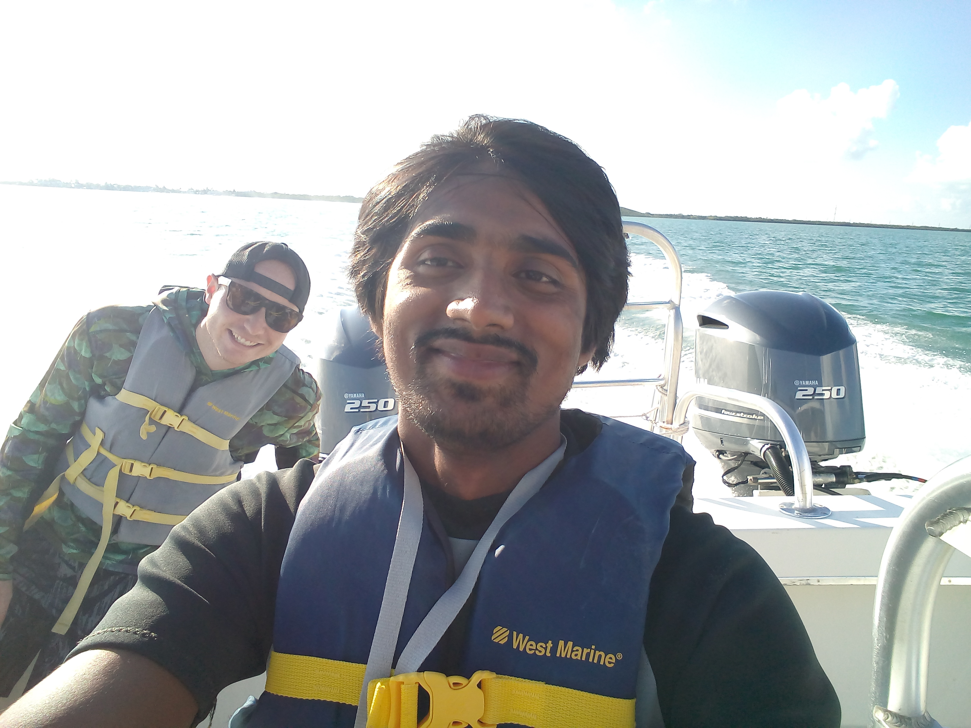
Field working in the Keys Marine Laboratory ,Florida , USA
The Keys Marine Laboratory (KML) is a full-service marine field station situated in the heart of the Florida Keys.
I I have spent three days there and done a lot of field works,lab works and research under the supervision of Dr. Douglass.
We dived into the Gulf of Mexico and the Atlantic Ocean and Identified Seagrass,Marine fishes and Coral reefs species.
Working in the Marine Ecology Lab
This is Dr. Douglass's Ecological lab. I spent about 86 hours in the last fall 2019 semester.
I worked on Benthic Samples and sorting with four graduate students of the Florida Gulf Coast University.
Leadership program
The Social leadership Hackathon is a half-day workshop where students from diverse backgrounds can come together to
learn and exercise leadership to solve a problem in their community.
Participants will work in small groups to focus on a particular local problem and work together as a team to create an action plan to solve it.
Atlantic Ocean !
I love Oceand and its Weather. I dived into the Ocean.
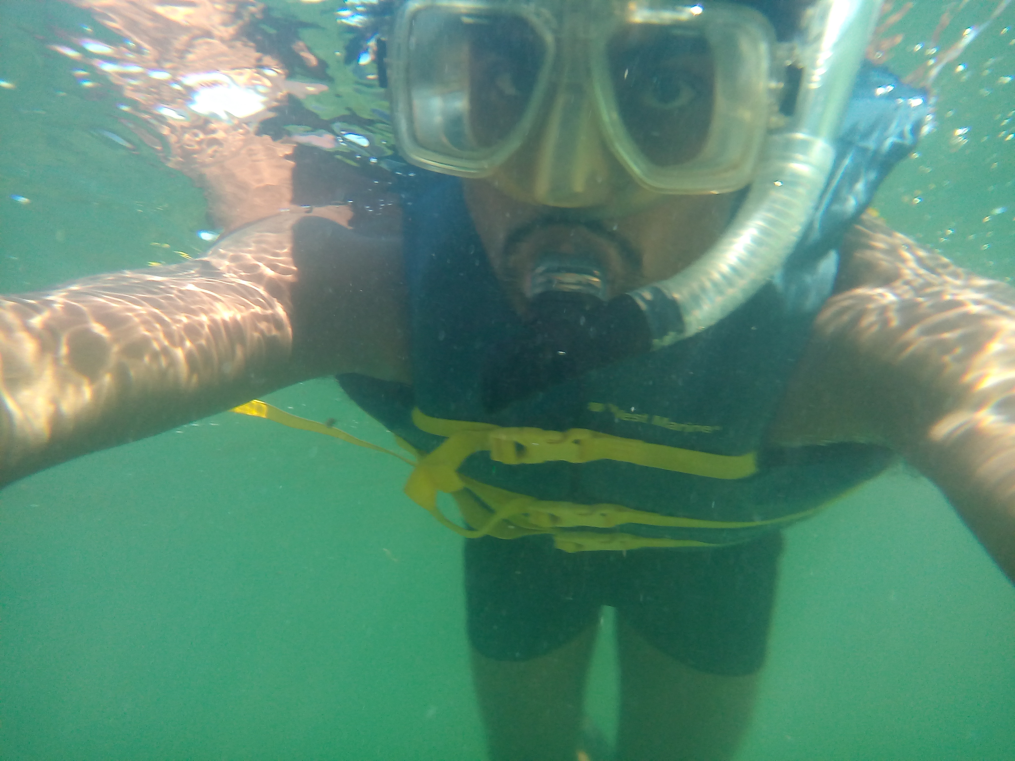
Snorkeling in the Gulf of Mexico
This was part of our Marine Ecology course. we collected fish and seagrass samples from different spots
of the Gulf of Mexico. then We identified all of them at the Laboratory.
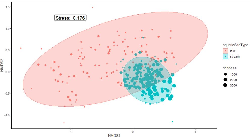
Community Ecology
Community Ecology :study of the interactions between species, such as mutualism, predation and competition, and the dynamics and structure of the community.
I did some analyses on Nonmetric multidimensional scaling using R.
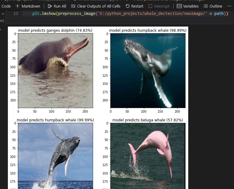
CNN_MarineMammal_Prediction
This is a basic Marine Mammal and Sharks detection-based on convolutional neural network model from static images. The classification stage is now complete; after some months, I will update the entire code for mammal and shark detections.
At first , I used VGG-19 pretrained CNN model, then I built a new simple CNN model.
The convolutional Neural Network CNN works by getting an image, designating it some weightage based on the different objects of the image, and then distinguishing them from each other.
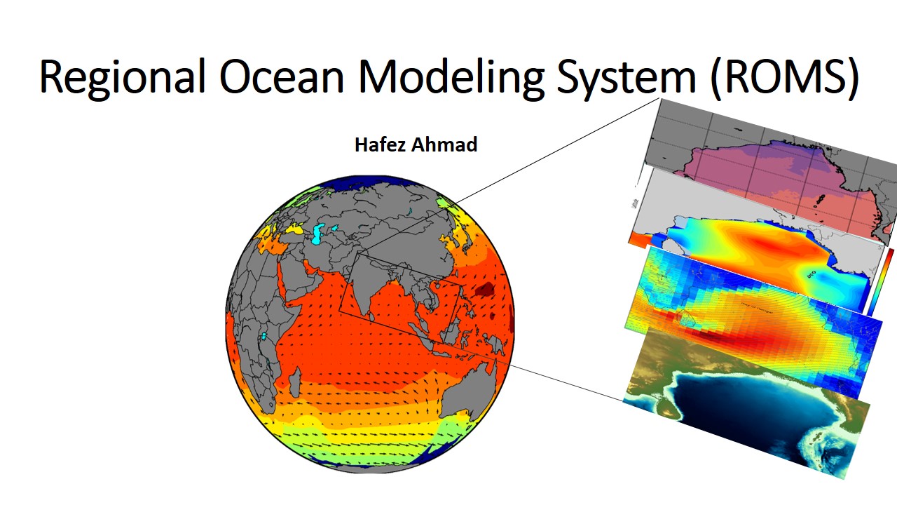
Ocean models are numerical models with a focus on the properties of oceans and their circulation. Ocean models play a large role
in aiding our understanding of the ocean's influence on weather and
climate.I love to work in the Ocean Modeling . I have little experience in Regional Ocean Modeling system
by scientists to better understand the earth climate system.
Why do we need to Model Ocean?
Ocean models play a large role in aiding our understanding of the ocean’s influence on weather and climate.
They are a repository for mechanistic theories of how the ocean works with numerical methods used to transform the mathematical expression of the theories into
a computational tool for scientific investigations. In particular numerical models are for hypothesis-driven experimental and theoretical studies that
make them an essential tool in the hierarchy of methods used
by scientists to better understand the earth climate system.
Ecological Modeling
Ecosystem modeling is the mathematical representation of ecological systems from individuals to the whole biome
which is studied to understand the real nature, the models can be analytic or simulations based.
It has applications in a wide variety of disciplines.
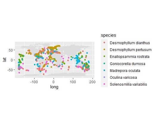
Coral shallow and deep-water species distribution
author: Hafez ahmad
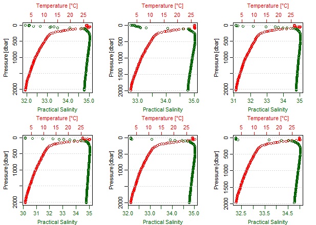
Vertical Ocean Temperature and salinity with pressure distribution
this is created by R using Argo data. author: Hafez ahmad
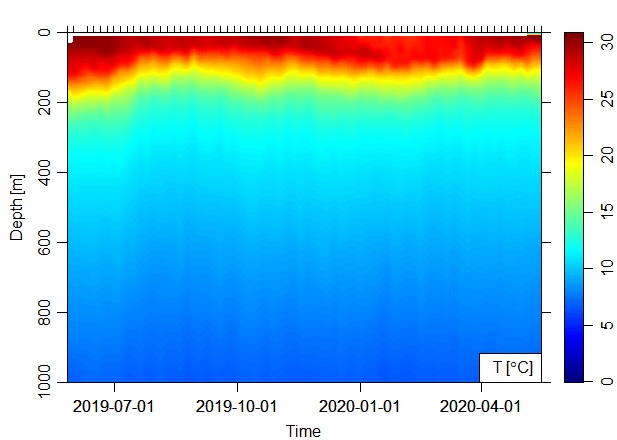
Depth Ocean temperature in the Bay of Bengal
this is created by R and Python using Argo data. author: Hafez Ahmad
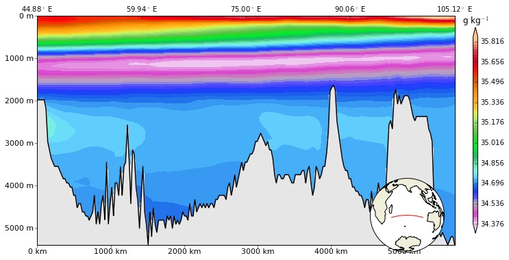
Cross sectional plot of the Indian Ocean
Cross sectional Plot: A section plot is a vertical "slice" through the ocean, along an alignment that is often a straight line,
portraying the vertical structure of a selected property along the alignment.
this type of plot is extremely useful in the case of multidimensional data analysis. I made it using Python programming for the presentation purpose.
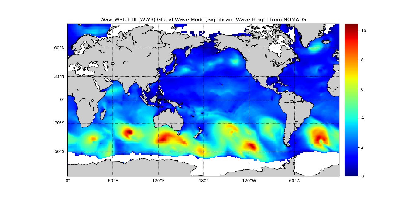
Significant wave height of the Ocean
author: Hafez ahmad ,data source : NOAA's WAVEWATCH III (
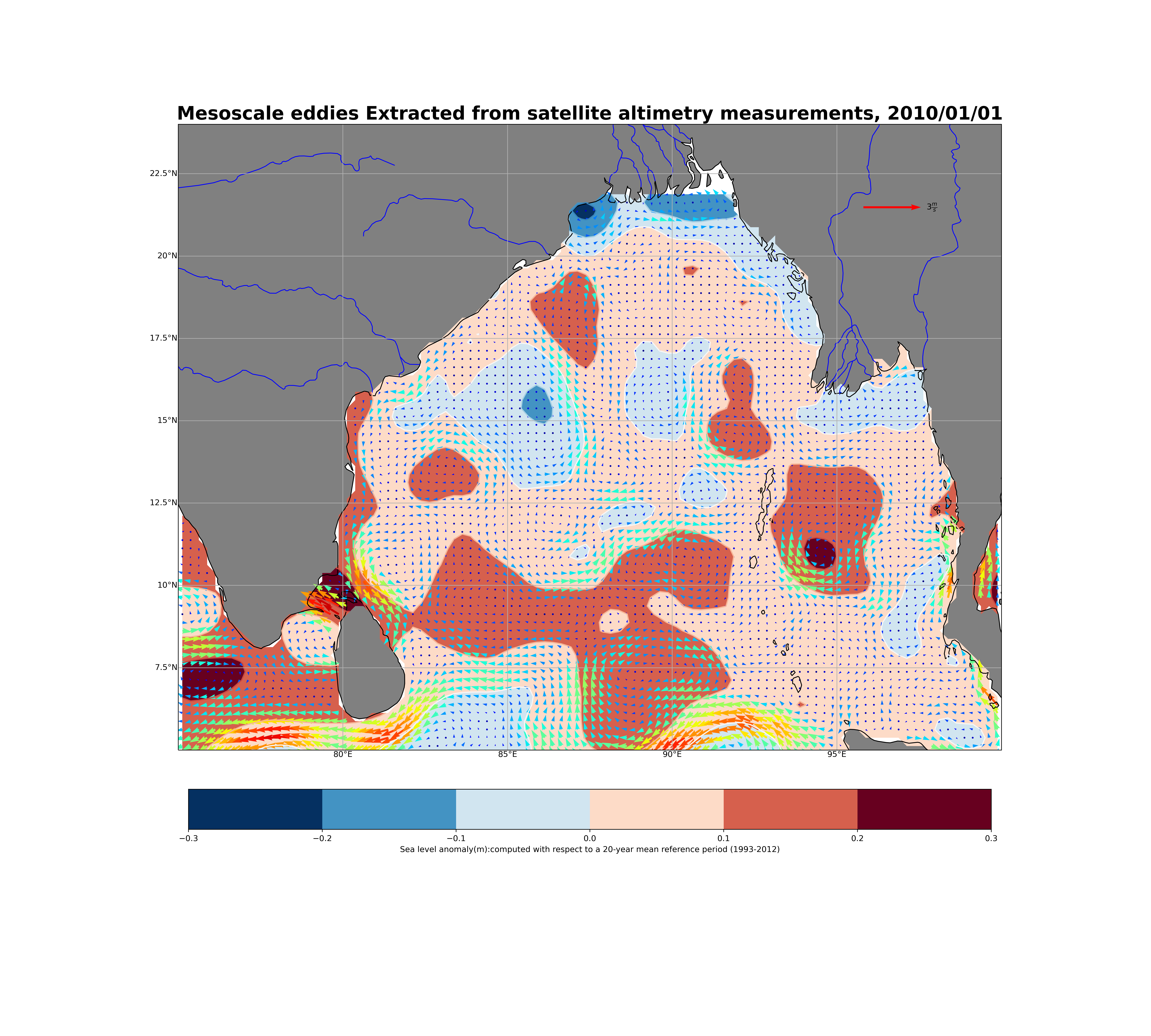
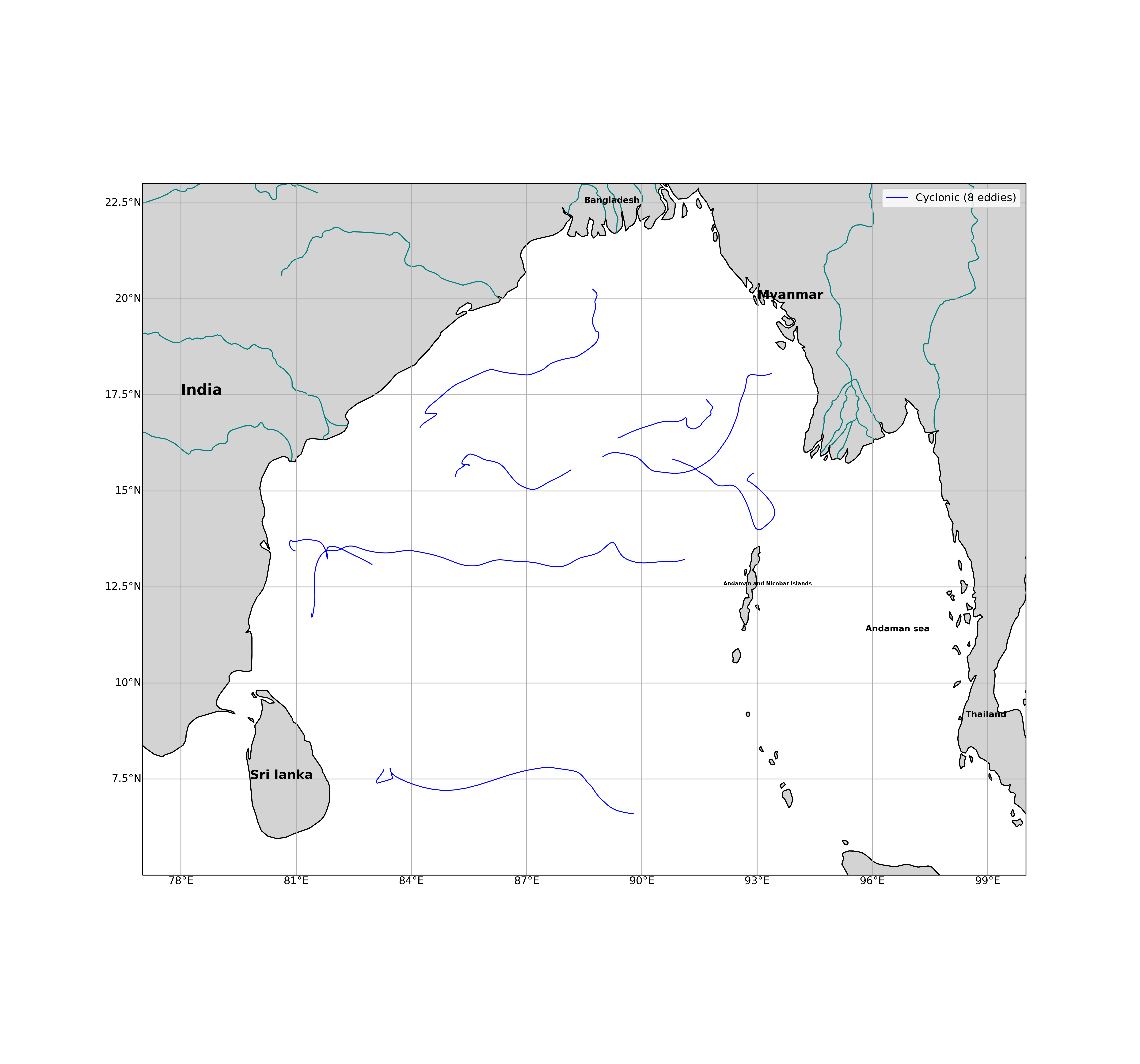
Mesoscale Eddies Extracted from Satellite Data
Have you noticed that offshore, the eddies are warm, while near the River mouth, water is cold and lower SLA values
Mesoscale Cyclonic Eddies those are longer 10 weeks
Mesoscale cyclonic eddies (cold core) are though known to enhance the phytoplankton biomass in the Bay of Bengal,
their contribution to the carbon export to the deep ocean are yet to be quantified.Eddies exist principally in the western Bay of Bengal and most of them propagate westward. The polarity distribution of eddies shows cyclones prefer to occur in the northwest and south of the Bay of Bengal,
while anticyclones mainly occur in the east of the bay.
Sample works on Traditional data analysis and visualization
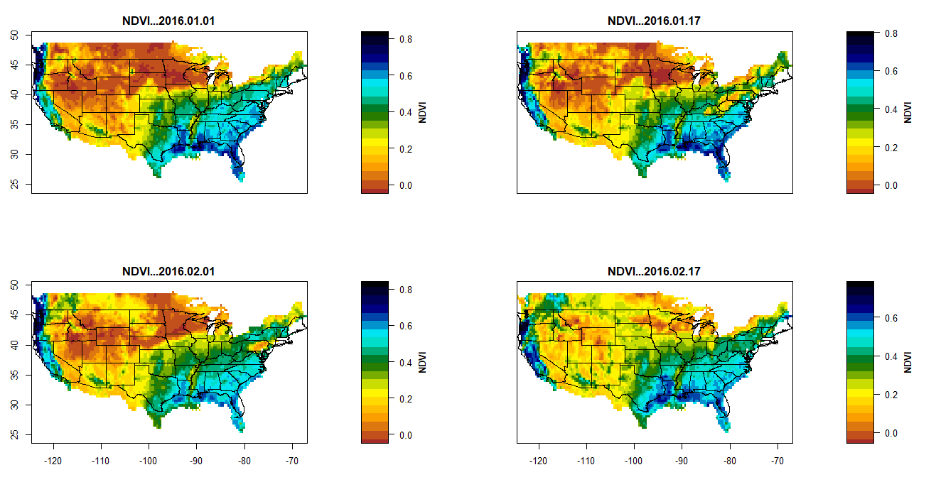
Normalized difference Vegetation Index(NDVI) with R
Sample works on data analysis and visualization on SDM with R
Remote Sensing (RS) has a wide range of applications in the field of physical, biological, coastal, and satellite oceanography. RS in Oceanographic research is the collection of oceanographic, monitoring of coastal and oceanic processes data, and analysis of various processes using space-borne and airborne sensors.
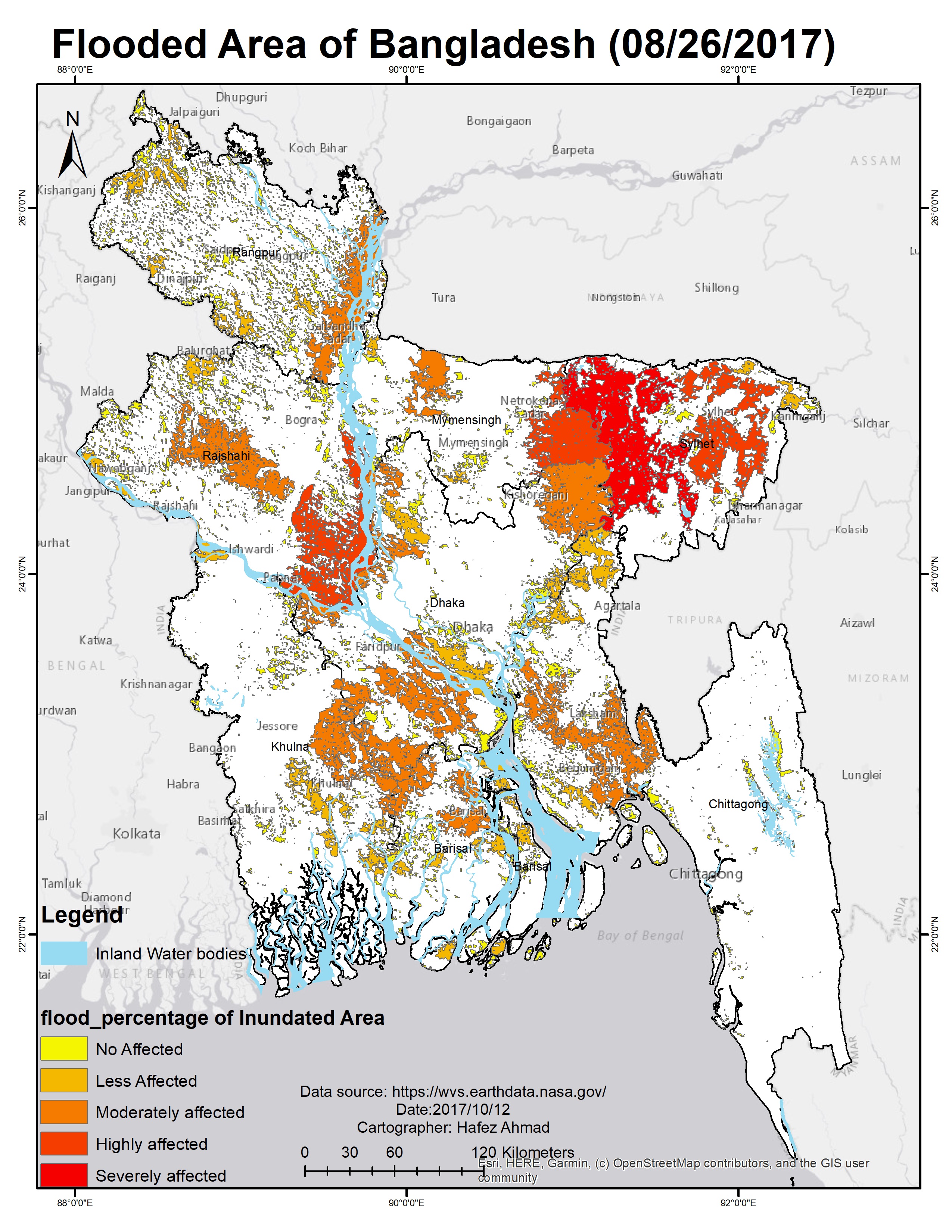
Each year in Bangladesh about 26,000 square kilometres (10,000 sq mi) (around 18% of the country) is flooded, killing over 5,000 people and destroying more than seven million homes. During severe floods the affected area may exceed 75% of the country, as was seen in 1998. This volume is 95% of the total annual inflow.
Application of remote sensing data in Oceanographic Research
Some important variables from Remote sensing Data
No.
Parameters
Satellite sensors
Uses
1
Sea surface temperature(SST)
MODIS,AMSRE,TMI
Helps in the study of climate change and weather forecasting.
2
Total suspended solids (TSSs)
DEIMOS-1,LANDSAT ,ASTER
Provides information on hydrodynamic modeling of the coast.
3
Sea surface salinity (SSS)
ESA Soil Moisture and Ocean Salinity (SMOS),SMAP SSS
Helps in monitoring salinity.
4
Chlorophyll content
SeaWiFS, IKONOS, IRS P4 OCM
Helps in monitoring phytoplankton blooms and concentration of phytoplankton.
5
Sea surface height (SSH),wind speed
Topex /Poseidon, ERS-1 , ERS-2
Helps in monitoring ocean currents,eddies and waves.
6
Surface current, front, circulation
POES/AVHRR, GOES/IMAGER, JASON-1
Helps in monitoring ocean currents,waves and Wave and current modeling.
7
Potential fishing zone
NOAA AVHRR, IRS OCM
Helps in monitoring fishing zone.
8
working
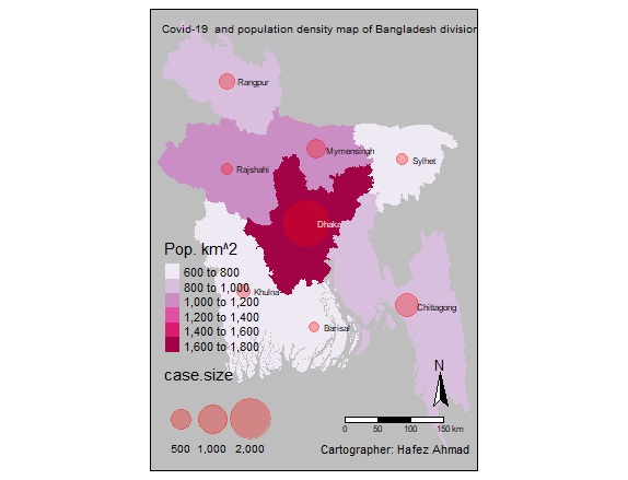
The relation between Covid-19 and Population density Map
Dhaka is the capital of Bangladesh.More than 19.5 million people live in Dhaka, the capital of Bangladesh. That's more than 23,234 people per square kilometer. most of the confirmed Covid-19 case are from this area
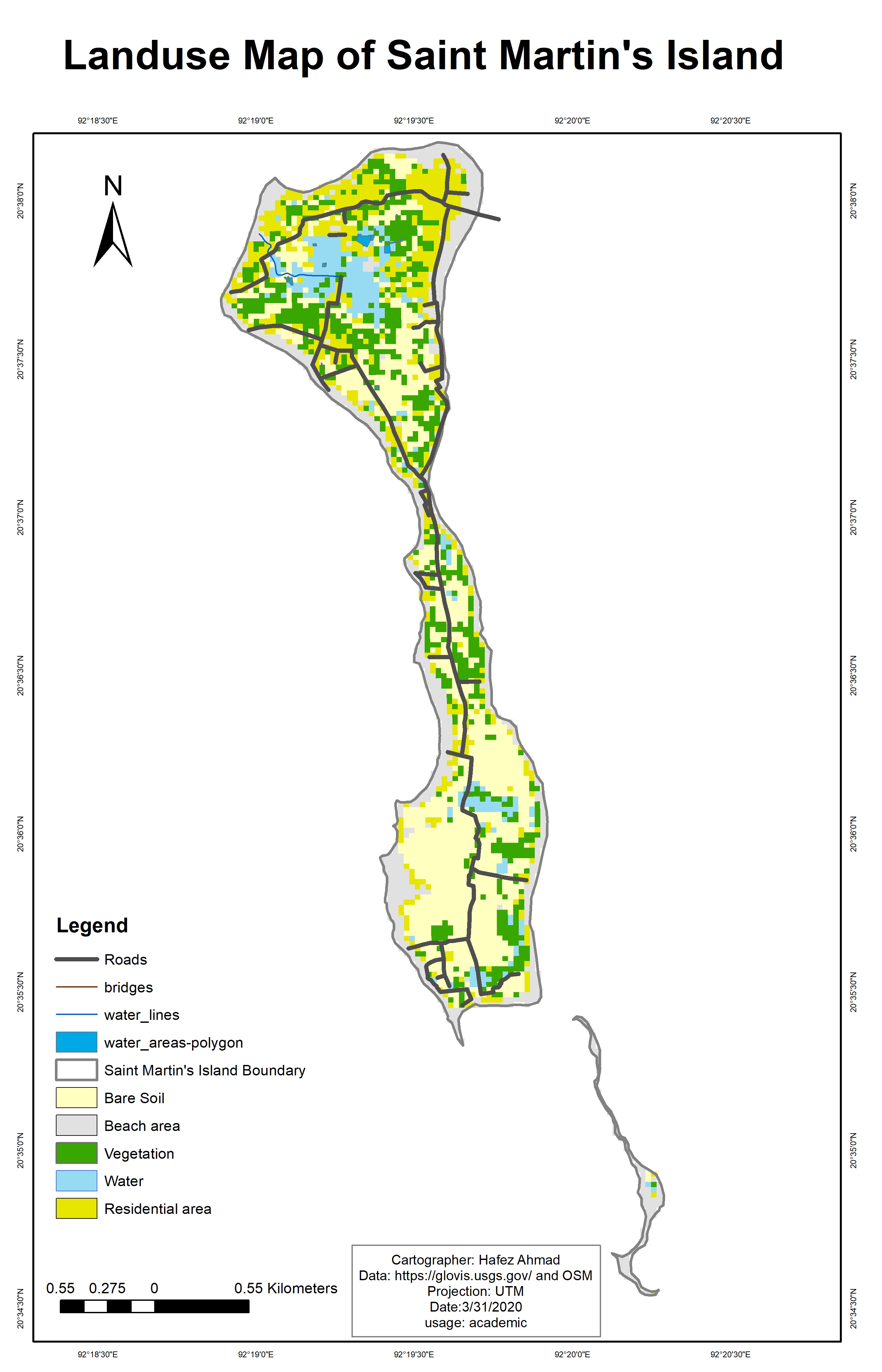
Saint Martin island Landuse land cover Map
St. Martin's Island is a small island in the northeastern part of the Bay of Bengal,
about 9 km south of the tip of the Cox's Bazar-Teknaf peninsula,
and forming the southernmost part of Bangladesh.
it is enriched with numerous marine biotic and abiotic resources including many species of commercial fishes,
coral reefs, marine algae, mollusks, etc. that has been playing a significant role for the socio-economic development
of the islanders. the social-economic conditions of the local
community are completely dependent on both Marine resources and tourism.
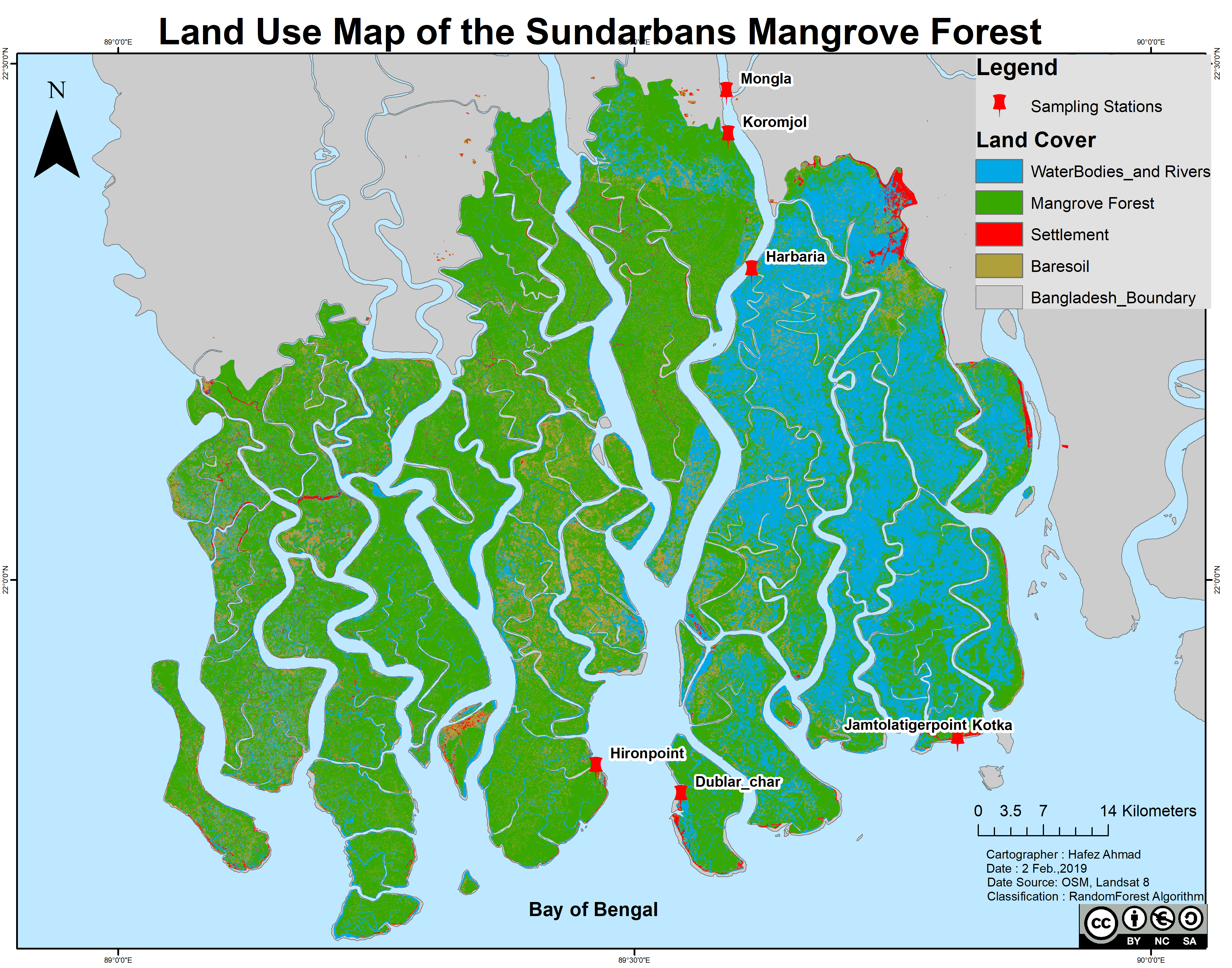
Landuse land cover Map of the Sundarbans Mangrove Forest,Bangladesh
Sundarbans is the largest natural mangrove forest in the world. It lies between latitude 21° 27′ 30″ and 22° 30′ 00″ North
and longitude 89° 02′ 00″ and 90° 00′ 00″ East and with a total area of 10,000 km2,
60% of the property lies in Bangladesh and the rest in India .
Image classification methods
Random forest(RF) is a supervised learning algorithm.The "forest" it builds, is an ensemble of decision trees,
usually trained with the “bagging” method (Breiman, 2001).This algorithm is used for satellite image classification using google earth engine and landsat 8 imageries.
Breiman proposed RF in 2001 for classification and clustering. RF grows many decision trees for classification.
To classify a new object, the input vector is run through each decision tree in the forest
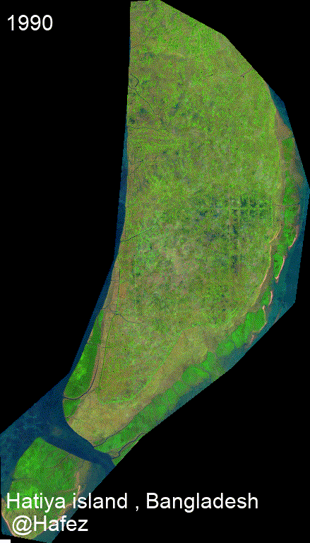
timelapse for small island for Bangladesh.
Surface water dynamics using Landsat Imageries
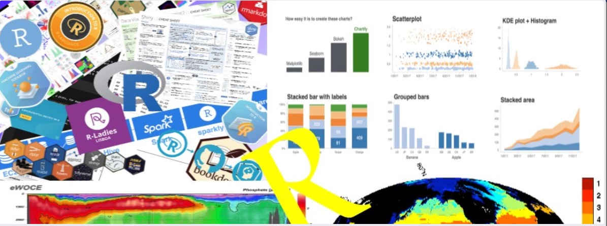
I love to teach Geospatial data analysis , Environmental and Marine data management with Python, R , Julia , with Specific softwares like
ArcGIS, QGIS ,saga GIS as well as Google Earth engine .
and I try to write regularly in the social media.I also provide screen-cast training.
If you need any sort of assistance , You can reach me at "hafezahmad100@gmail.com" .
I conduct online training via Zoom or Google meet and Skype. it is person to person Teaching one hour everyday [can be modified with Special demand].
I also provide online /offiline Geospatial consultancy services
Conceptual plans and feasibility studies
Detailed surveys and investigations
Flood Inundation analysis
Environmental data analysis and Mapping
Data migration, conversion, capture, rationalisation, validation
Geoimage[Raster] processing analysts
And Don't underestimate the value of personal experiences when it comes to online courses.
I provide online services and the courses are listed below .
course payment can be negotiable
Basic R/Python/julia programming
Advanced R/Python programming for Data analysis and Visualization
Big-data analytics with python
Parallel Computing with Julia / (Dask) python
Advanced R/python programming for Oceanographic Data analysis and Visualization
Ecological data analysis with Python/R programming
Advanced statistics with R programming
Geo-spatial data analysis with Python/R
Numerical analysis with Julia programming
Spatial analysis and Map Making with ArcGIS
land use and land cover Mapping with ArcGIS
Advanced ArcGIS online dashboard
Map Making and Modeling with QGIS
Data analysis with Matlab
Basic Equations solving with Matlab
Basic to advanced MS excel training
Online Academic Tutoring
If you think those topics are useful then you can email me with full requirements
or If you like to have a trial run, demonstration class that's awesome, I like to
run one hour trial on your specific topics class free of cost! I'll assure you that you will not to get panic in this or that topic.
I'll try to give you the real Information,
I'll teach you more easier way or what ever you choose, Of any problem you face i can solve that
3_Days with Multidimensional Data analysis and Visualization
Download course's outline
If you face any problems regarding downloading the course's outline, please send me email/ directly contact with me.
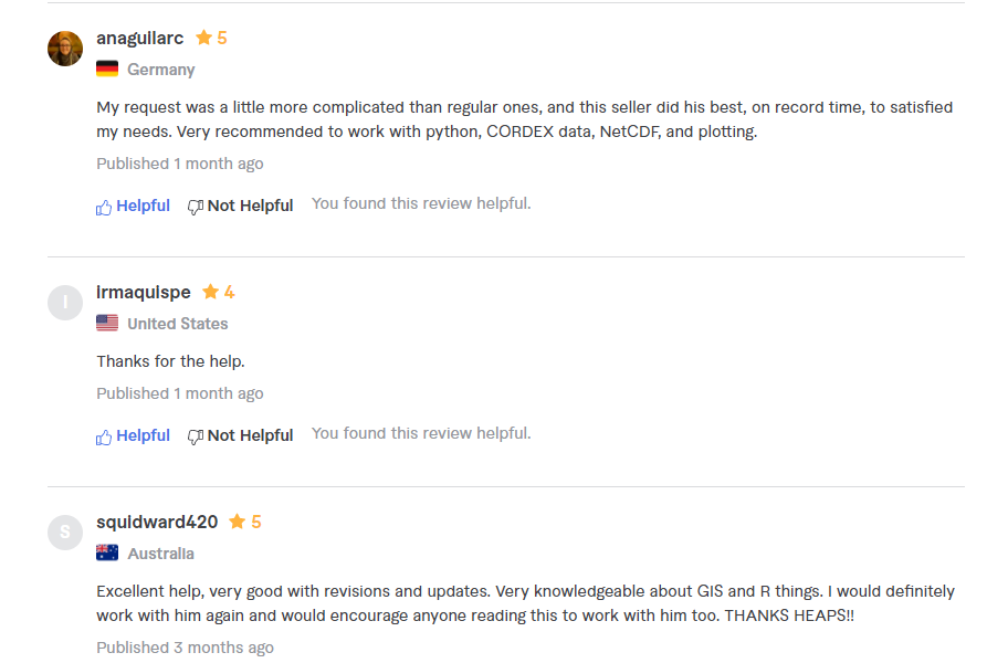
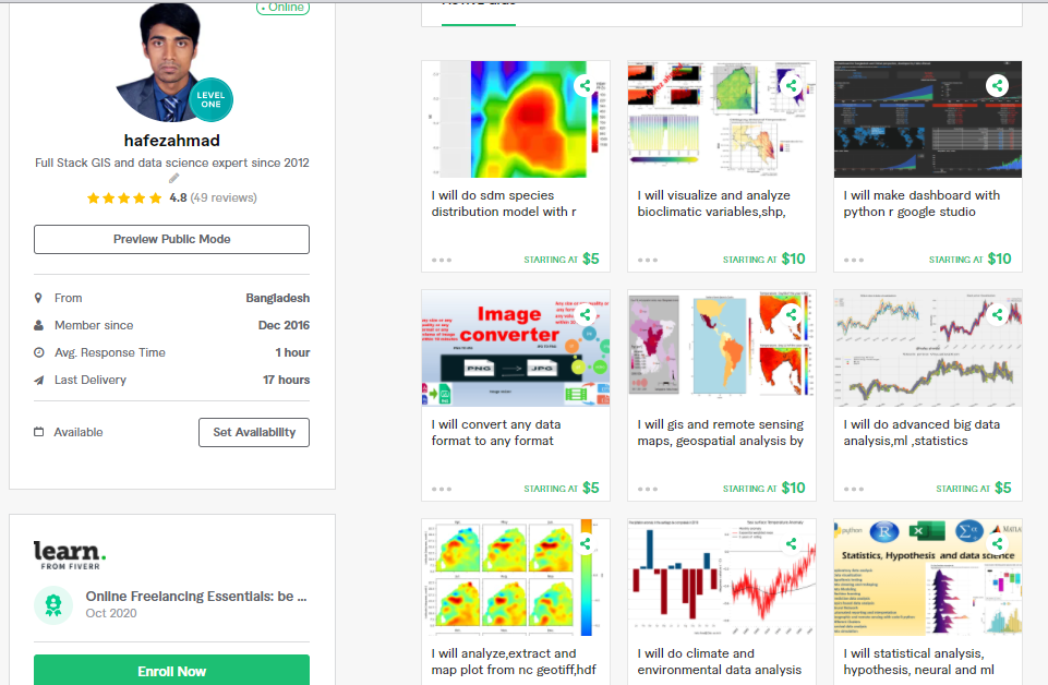
Some online clients reviewed my works and their comments (from 2018-2021)
I also provide online services as freelance work. you can find me here [https://www.fiverr.com/hafezahmad] and you order your work on desired topics data analysis / data visualization /problems / research findings/ problem identification.
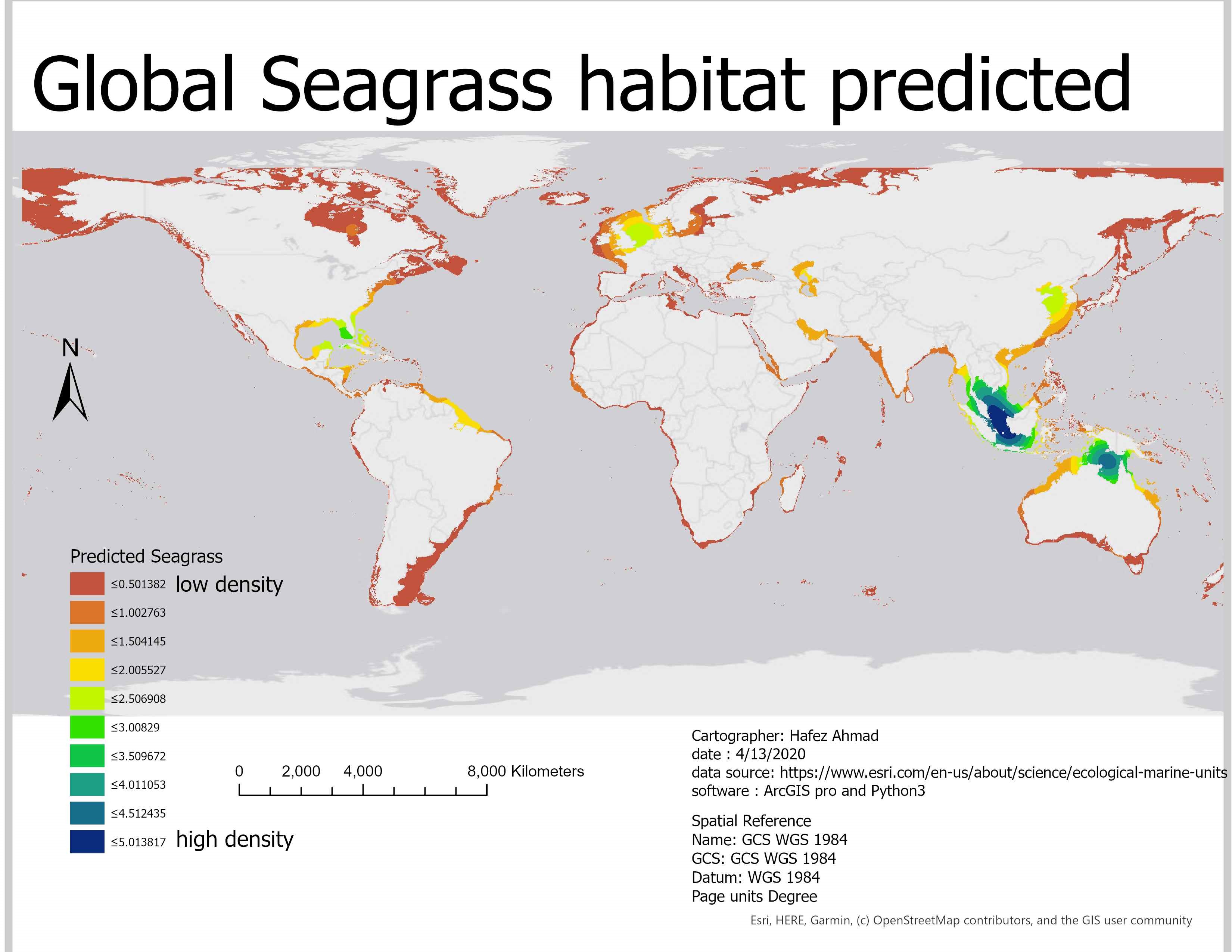
Predicted Seagrass across the world shallow ocean with Machine learning method ( Python3 package:- scikit learn). Alaskan pollock is one of the important species for commercial fishing in the north pacific ocean supporting various fisheries. To fish both efficiently and sustainably,
it is important to understand where shoals are most likely to be located. I am trying to apply geostatistics and build a model to temperature data to predict where to find them in the Bering Seahere the Link .
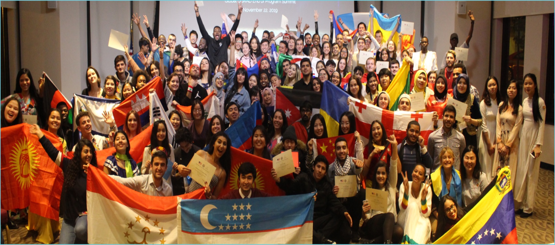
Global Undergraduate Exchange program,2019.
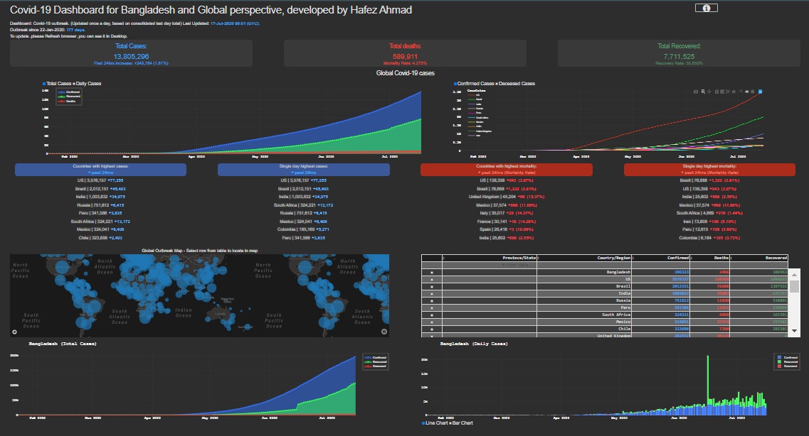
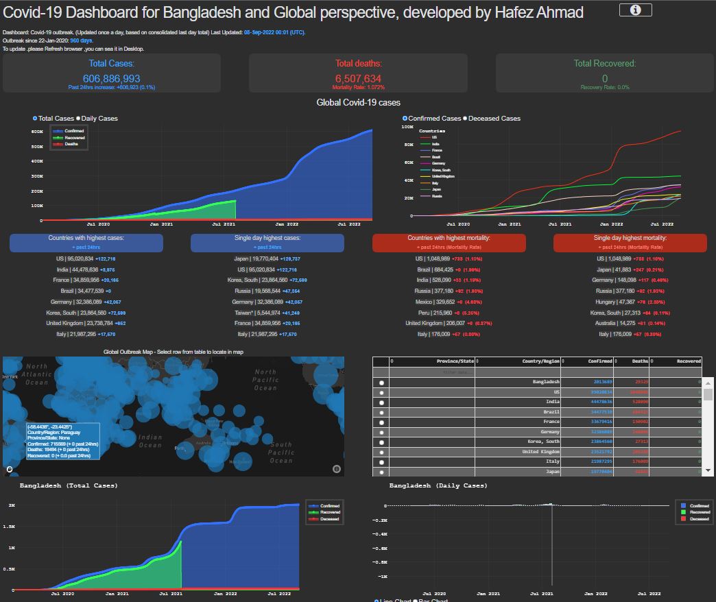
I have developed Covid_19 interactive Dashboard. It is extremely useful for the real time information.additionally , I made a SMS alert system for Covid-19 pandemic.
My contribution [notification system, dashboard, and prediction model]
I love to work in the field of Oceanography/Marine Science,Wildlife science,climate science,Ecology,Hydrology,Mapping (GIS, RS,hydrography) and Data analysis.If you think that I would be grateful if you would give me the possibility to join your research group and lab.I believe that with my scientific background, enthusiasm, curiosity, and determination, I could give a significant and valuable contribution to your research works and I also enjoy sampling, conducting fieldwork, and collecting data, you can contact with me at any moment.
 timelapse for small island for Bangladesh.